- Thumbnail
- Resource ID
- 01a7db1b-6f6b-11e9-8d7d-000d3ab6a624
- Title
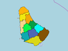
- TM-BRB_Administrative Districts- 2000 - 1:5000
- Date
- May 5, 2019, 2:21 p.m., Publication
- Abstract
- Parish boundaries and coastline for Barbados as digitized from Lands and Surveys Department survey maps which were created using 1982 aerial photography. The source maps varied in scale from 1:1250 to 1:5000 (higher resolution in urban areas) and were digitised by Bell Canada under contract from Bartel. The original coordinate system of the survey maps was Barbados 1938 grid (BNG). The island is currently divided into 11 parishes
- Edition
- --
- Owner
- gridanode
- Point of Contact
- devrsgis@gmail.com
- Purpose
- --
- Maintenance Frequency
- None
- Type
- not filled
- Restrictions
- None
- None
- License
- None
- Language
- eng
- Temporal Extent
- Start
- --
- End
- --
- Supplemental Information
- No information provided
- Data Quality
- --
- Extent
-
- long min: -59.6510559587
- long max: -59.4200776448
- lat min: 13.0447950251
- lat max: 13.3351479298
- Spatial Reference System Identifier
- EPSG:900913
- Keywords
- no keywords
- Category
- None